
Overview
The Soarvo Map Window includes built-in tools for linear, area, and volumetric measurements — available to all roles with location access.
Using Measuring Tools
Select the measure tool to use in the map window
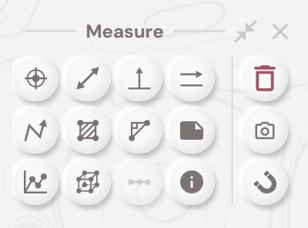
The options available are:
- Point Coordinate - Show Lat/Lng/Elevation and Projected Co-ordinate
- Line Distance - Click 2 points to show distance between them
- Height from Terrain - Click 2 points to show height above terrain
- Horizontal Distance - Click 2 points to see horizontal distance between them
- Polyline Distance - Click multiple points to see total length of line and section lengths
- 2D Area - Click a polygon shape to see calculated 2D area
- Component Distance - Click 2 points to see heights, distances and angles
- Notes - Add a comment to the data - comments are shared across all users
- Cross Section - Click multiple points to calculate Cross Section across data shown
- Volume Calculation - Click multiple points around an area you want to calculate the volume
- Generate Points Along Line - Select a polyline and then enter the distance you want to generate points along it.
- Feature Info Tools - Select to show feature attributes from .WMS or .IFC files
- Clear Measurements - remove all measurements from the plan
- Take A Screenshot - take a screenshot of measurements and save as .JPG for reports
- Enable Snapping - enable snap to feature for feature editing, or snap to surface for taking point cloud measurements
⚠️ Note: Volume calculations require point cloud or 3D mesh data loaded in the location.
What's Next?